
Examining Bugiri-Chato National Park’s splendor
April 28, 2026
Discover Tanzania’s Best Wildlife Conservation Projects and Initiatives
April 28, 2026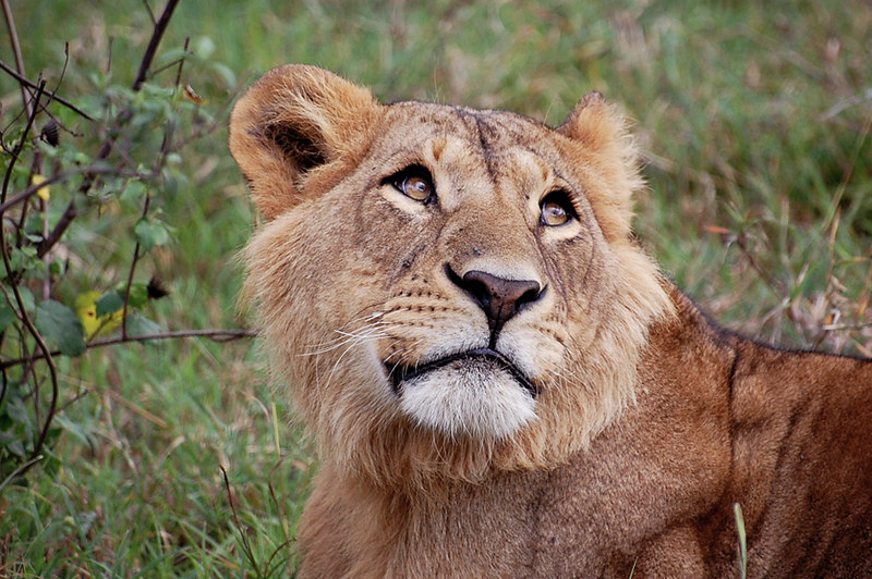

Budget-friendly tourist destinations in Nakuru for families include:
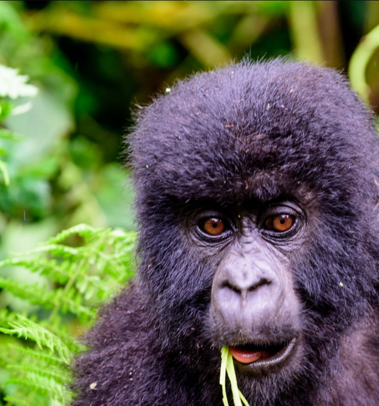
The city of Nakuru is located in Kenya’s Rift Valley. It is the third largest city in Kenya and the county capital of Nakuru. With 570,674 urban residents as of 2019, Nakuru has surpassed Eldoret in Uasin Gishu County to become the largest urban hub in the Rift Valley.The park was declared a rhino refuge in 1988. Additionally, it was named an Important Bird Area in 2009 and a Ramsar site in 1990.The park’s enormous flamingo population has earned it international recognition. It serves as an essential feeding place for the great white pelicans that nest in neighboring Lake Elmenteita. Over 450 different bird species and 56 distinct mammal species, including Rothschild’s giraffes, may be found in the park.
Nakuru Lake
One of the Rift Valley’s lakes, Lake Nakuru, is well-known for the magnificent flamingos that border its shore. Situated south of Nakuru town, Lake Nakuru National Park protects it and it is 1,754 meters (5,755 feet) above sea level. The abundance of algae in the lake attracts a lot of flamingos to the beach. In addition to the birds, there are many baboons, warthogs, and other large creatures. Black rhinos from the east and white rhinos from the south have also been brought in.
The lake’s water level drastically dropped in the early 1990s, but it has since largely recovered. Following a startling increase in the lake’s water levels in 2013, flamingos came to Lake Bogoria in search of food. Nakuru means “Dust or Dusty Place” in Maasai. Adjacent to Nakuru town, Lake Nakuru National Park was created in 1961. At first, it just covered the famous lake and the surrounding mountains, but it has since expanded to cover a sizable area of the savannahs.
National Park at Lake Nakuru
The 188 km2 (73 mi2) Lake Nakuru National Park, which is near Nakuru Town, was created in 1961. What makes it famous are the thousands, maybe millions, of flamingos that breed along the shorelines. The tiny lake’s surface is obscured by a mass of pink that changes regularly, making it hard to tell it apart from other items. Baboon Cliff offers the best vantage position, and the amount of flamingos on the lake varies according to the water and food conditions. Notable is also a 188-kilometer (117-mile) area surrounding the lake that has been designated as a giraffe and black and white rhino sanctuary.
The park was recently enlarged, partly to provide a sanctuary for black rhinos. Building a fence was necessary for this project, although it was done to discourage poaching rather than to halt wildlife migration. The park stretches 12.1 km (7.5 mi) along the southeast boundary with the Soysambu conservancy, which serves as both a prospective future rhino habitat extension area and the final remaining wildlife corridor to Lake Naivasha.
About 70 southern white rhinos and about 25 eastern black rhinos, one of the highest densities in the country, were found in the park as of 2009. Additionally, there are some Rothschild’s giraffes, which were relocated from western Kenya starting in 1977 for safety.This area is home to both of the Kenyan waterbuck subspecies, which are rather common. Predators include lions, cheetahs, and leopards, the latter of which has increased significantly in recent years. There are also large pythons in the park, which inhabit the thick forests and are often seen straying from trees or crossing roads. Numerous additional bird species, including flamingos and others of their kind like the African fish eagle, Goliath heron, hammerkops, pied kingfisher, and Verreaux’s eagle, can be found in the lake and its environs.
The Menengai Crater
The massive shield volcano Menengai Crater, located in Kenya’s Great Rift Valley, is home to one of the world’s largest calderas. It is the biggest volcano caldera in Kenya and the second largest in Africa.Rich loam soils produced by volcanic activity enhance the area around its flanks. The crater is near the bottom of the Rift Valley. About 8000 years ago, a 12-by-8-kilometer volcano and caldera formed. The volcano formed about 200,000 years ago. Numerous post-volcanic lava flows fill the caldera’s floor. There is a somewhat well-preserved Krakatau-style caldera on the Menengai volcano. Silt is quite rare in Menengai’s caldera, which is made up of difficult ridges and massive lava stones.
Menengai Forest Menengai Crater
The Menengai Crater is located in the center of the Menengai Forest, which is close to the town of Nakuru. This region was gazetted as a forest in the 1930s. From west to east, Ngachura and Bahati are the closest residential neighbourhoods; south, Milimani Estate; and north, Olo-Rongai. Set separate from the jungle are two government buildings in Kenya: Kenya Broadcasting Corporation and Nakuru General Prison. A project to explore for geothermal energy is being carried out beneath the Menengai Crater by the Geothermal Development Company. There are animals, insects, and birds in the forest. Some of the Mammals include the olive baboon, Kirk’s dik-dik, black-faced vervet monkey, rock hyrax, and mountain reedbuck. Other bird species include African spotted eagles, African marsh harriers, Abyssinian ground hornbills, turn-tailed ravens, Horus swifts, and Verreaux’s eagles (found only in Menengai Forest, Nakuru). Spiders, butterflies, and molluscs are among the other animals.
Hyrax Hill
A ancient site called Hyrax Hill can be found in Kenya’s Rift Valley province close to Nakuru. It is a rocky outcrop that is about half a km long and rises to a summit elevation of 1,900 metres above sea level. Louis Leakey made the initial discovery of the site in 1926 while conducting excavations at the neighbouring Nakuru Burial Site. Mary Leakey carried out the first significant excavations between 1937 and 1938. At Hyrax Hill, there are two separate zones of occupation: one from the Pastoral Neolithic and the late Iron Age, and the other from the Sirikwa’s earlier Iron Age.
The hyrax is a small mammal that inhabits rocky places, and Hyrax Hill is named after it. Hyraxes were originally widespread in the rocky holes of Hyrax Hill, but their numbers have decreased recently as a result of the area’s quick urbanisation.
Louis Leakey discovered ancient villages on Hyrax Hill in 1926 while doing excavations for the nearby Nakuru Burial. He felt it was a relatively recent dwelling and decided not to dig it at the time because he had other sites to work on. Louis Leakey returned to the area in 1937 with his wife Mary Leakey. Mary Leakey began the primary excavations at Hyrax Hill. She identified and excavated both Site I and Site II between 1937 and 1938.
Dating the sites at the time was challenging because there was no carbon dating technology. Leakey mischaracterized the Iron Age “Sirikwa Holes” as an earlier settlement with “pit-dwellings.” After the National Museums of Kenya acquired Hyrax Hill in 1965, excavations at the site did not resume until Ron Clark and museum personnel completely excavated one of the Sirikwa holes for the museum’s display.
